Baltic Sea map gets attention for looking like a crocodile eating Finland
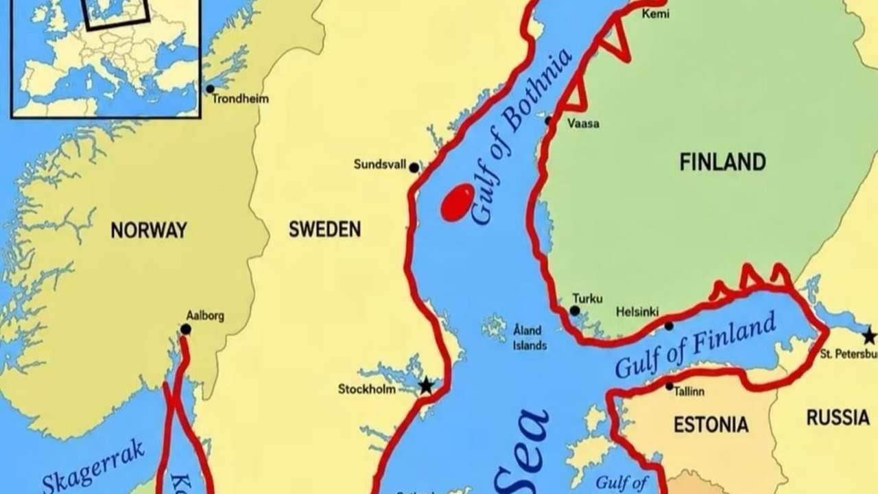
Geography sometimes produces shapes that look unexpectedly familiar. In the case of the Baltic Sea, its winding coastline can be traced into something resembling a crocodile with its jaws wrapped around southern Finland.
Key points
- The Baltic Sea resembles a crocodile on some maps
- The Gulf of Finland forms the apparent jaws
- The sea covers about 420,000 square kilometres
Geography sometimes produces shapes that look unexpectedly familiar. In the case of the Baltic Sea, its winding coastline can be traced into something resembling a crocodile with its jaws wrapped around southern Finland.
The resemblance is an example of pareidolia, the tendency to recognise familiar shapes in otherwise unrelated patterns. On the map, the Baltic Sea forms the crocodile's body, while the Gulf of Bothnia, stretching north between Sweden and Finland, resembles its long tail.
The illusion becomes particularly clear around Finland. The Gulf of Finland, which runs east between Finland and Estonia towards St. Petersburg, forms the lower jaw, while Finland's southern coastline completes the upper side of the mouth.
There is, of course, no geographical significance to the crocodile shape. It depends on how the coastline is outlined and how the viewer interprets it.
RECOMMENDED FOR YOU

Lula supporters take to Brazil's streets, warn far-right fight is not over
A sea almost enclosed by Europe
Beyond the visual joke, the Baltic has an unusual geography of its own. It covers roughly 420,000 square kilometres and is surrounded by nine countries: Denmark, Estonia, Finland, Germany, Latvia, Lithuania, Poland, Russia and Sweden.
It is also relatively shallow. HELCOM puts its average depth at about 52 metres, with its deepest point reaching 459 metres at the Landsort Deep. More than a third of the sea is less than 30 metres deep.
The Baltic is connected to the North Sea through narrow Danish waterways, which limit the movement of ocean water into and out of the basin. HELCOM estimates that a complete exchange of its water takes roughly 30 years.
That slow exchange, combined with freshwater flowing in from numerous rivers, makes the Baltic one of the world's largest brackish-water areas; its water is less salty than typical seawater but saltier than freshwater. Salinity generally falls as you travel north and east.
So the crocodile may exist only in the eye of the viewer, but the geography creating the illusion is real: a long Gulf of Bothnia for a tail, the central Baltic for a body and the Gulf of Finland forming a surprisingly convincing open mouth.
This story is written and edited by the Global South World team, you can contact us here.