Canada and Mexico are the closest foreign countries to most of the United States
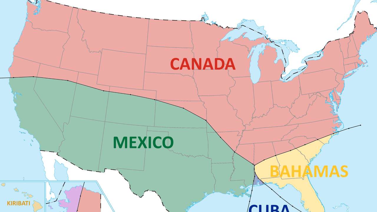
Canada is the nearest foreign country to a vast stretch of the northern and eastern United States, while Mexico dominates much of the South and Southwest, according to a geographic map illustrating which foreign country lies closest to different parts of U.S. territory.
Key Points
- Canada is closest to much of the northern and eastern US
- Mexico is nearest across much of the South and Southwest
- Russia lies just 2.5 miles from US territory in Alaska
Canada is the nearest foreign country to a vast stretch of the northern and eastern United States, while Mexico dominates much of the South and Southwest, according to a geographic map illustrating which foreign country lies closest to different parts of U.S. territory.
The map divides the United States according to straight-line proximity to foreign territory rather than political, economic or transport links. That produces some less obvious results, particularly in Florida, Alaska and the Pacific.
Canada emerges as the nearest country across much of the northern United States, extending from the Pacific Northwest through the Midwest and into the Northeast. Mexico is closest across much of California, the Southwest, Texas and sections of the southern United States.
The physical borders help explain much of that pattern. The U.S.-Mexico land boundary stretches 3,144 km, according to the International Boundary and Water Commission.
RECOMMENDED FOR YOU

France split into three nearly equal populations shows how unevenly the country is settled
Florida is where the map becomes considerably more complex.
The Bahamas is shown as the closest foreign country to much of the Florida peninsula and parts of the southeastern U.S. The Bahamian island chain sits remarkably close to Florida. Bimini, the westernmost district of the Bahamas, is about 80 kilometres or 50 miles east of Miami, according to geographic information published by the Bahamas government.
Cuba becomes the nearest foreign territory to parts of southern Florida and the Florida Keys, according to the map.
The result means that proximity in the southeastern United States cannot be understood simply by looking at America's two land-border neighbours. Caribbean islands can be geographically closer than either Canada or Mexico.
Alaska produces perhaps the map's most striking result.
Canada remains the nearest foreign country across much of Alaska, but Russia takes that position in parts of the state's far west.
The National Park Service says mainland Alaska and mainland Russia are separated by about 55 miles, while the Russian island of Big Diomede and the American island of Little Diomede are only about 2.5 miles apart in the Bering Strait.
NOAA similarly places the distance between Russia and Alaska at their closest mainland points at around 53 miles.
RECOMMENDED FOR YOU
Asia produces the largest share of global GDP
That makes Russia physically closer to parts of the United States than many Americans may assume from conventional world maps.
This story is written and edited by the Global South World team, you can contact us here.