India narrowly leads the US for the world’s largest area of arable land
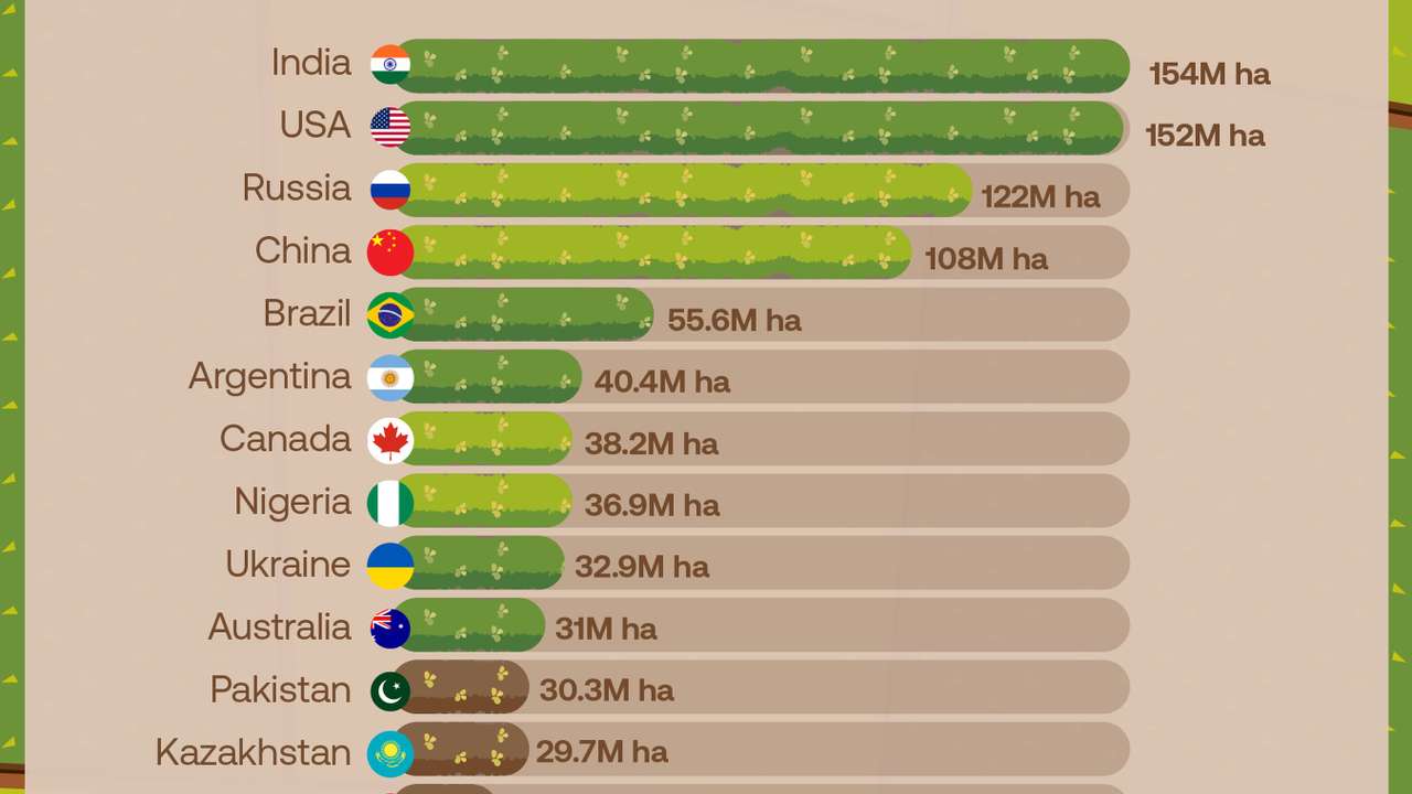
India has the largest area of arable land in the world, narrowly ahead of the United States, according to data compiled by the UN Food and Agriculture Organisation and published by the World Bank.
Main points
- India has about 154 million hectares of arable land
- The US follows closely with roughly 152 million hectares
- Russia and China are the only other countries above 100 million hectares
India has the largest area of arable land in the world, narrowly ahead of the United States, according to data compiled by the UN Food and Agriculture Organisation and published by the World Bank.
The figures shown on the map put India at about 154 million hectares, followed by the United States at 152 million hectares. Russia ranks third with about 122 million hectares, while China has around 108 million hectares.
Together, these four countries account for an enormous share of the land used for crops such as wheat, maize, rice and other temporary crops.
There is a large gap after the top four. Brazil ranks fifth with about 55.6 million hectares, followed by Argentina with 40.4 million and Canada with 38.2 million.
RECOMMENDED FOR YOU
Argentina equals Germany's record with fourth FIFA World Cup final defeat
Nigeria stands out in Africa with about 36.9 million hectares, ahead of Ukraine at 32.9 million and Australia at around 31 million.
Pakistan, Kazakhstan, Sudan, Mexico and Indonesia complete the 15 countries shown on the map, with figures ranging from roughly 30 million hectares in Pakistan to 17.8 million in Indonesia.
The ranking broadly reflects the latest figures available through the World Bank's arable-land indicator, which uses data supplied by FAO. The World Bank currently lists 2023 as the latest year for this dataset, so the map should ideally identify the data year rather than presenting the figures as 2026 measurements.
There is an important distinction behind these numbers.
FAO defines arable land as land used for temporary crops, temporary meadows and pastures and temporarily fallow land. It does not include permanent crops or permanent grazing land, and it does not measure all land that could potentially be cultivated.
That means a country can have a huge agricultural sector without ranking particularly high for arable land. Countries with extensive permanent pastures, orchards or plantations may have far more agricultural land than their arable-land figure suggests.
The figures also show that country size alone does not determine how much arable land a nation has. India is far smaller than Russia, Canada or the United States by total area, yet it has more land classified as arable than any of them.
Accuracy note: The map is broadly consistent with FAO/World Bank data, but the values are rounded and should be labelled with their reference year. It would also be more precise to say “countries with the most arable land” rather than implying that the figures cover all farmland or all potentially cultivable land.
RECOMMENDED FOR YOU

Asia and Europe dominated the world’s biggest cities in 1700
This story is written and edited by the Global South World team, you can contact us here.