UN backs new world map that shows Africa closer to its true size
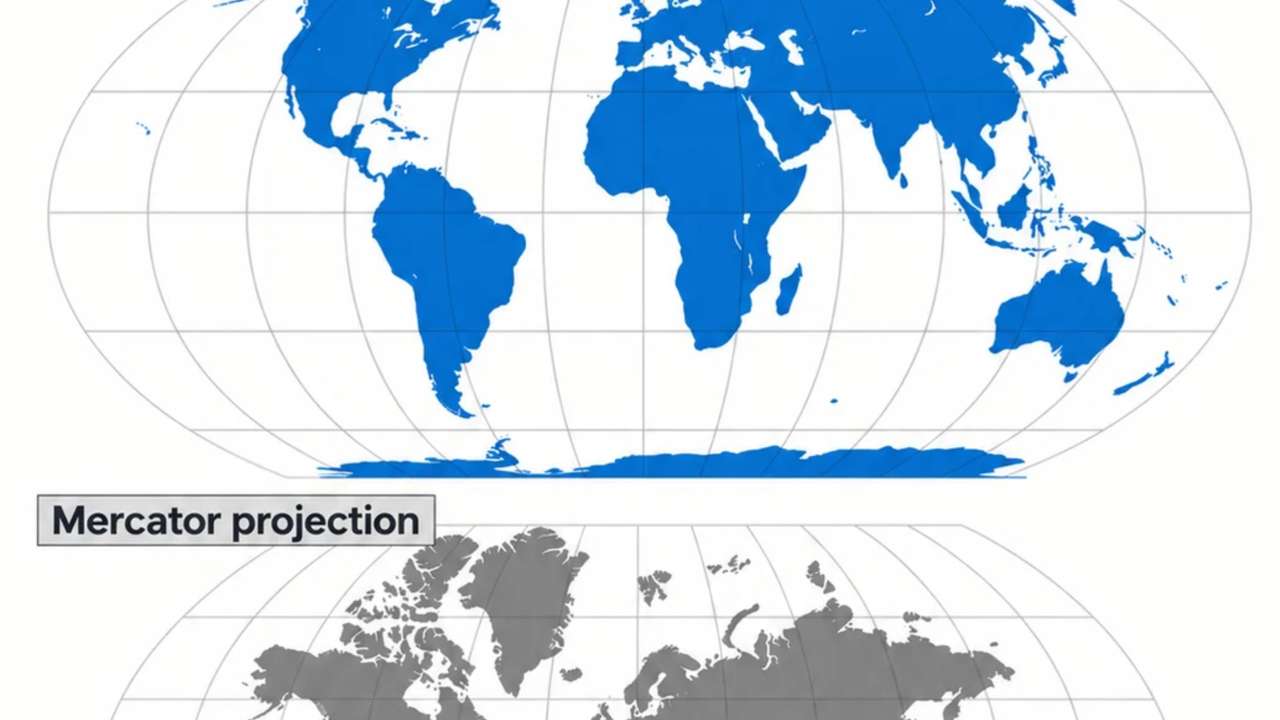
Key points
- The UN backed the Equal Earth projection
- The US was the only country to vote against
- The familiar Mercator map greatly distorts land size
The world is not changing shape, but one of the most familiar ways of looking at it could be.
The United Nations General Assembly has overwhelmingly backed a resolution encouraging wider use of the Equal Earth projection, a world map designed to show the relative sizes of countries and continents more accurately than the centuries-old Mercator projection.
The resolution passed on September 4 with 164 countries voting in favour. The United States was the only country to vote against it, while Estonia, Georgia, Lithuania, Moldova, Serbia and Ukraine abstained.
The move follows an African-led campaign challenging the way the Mercator projection represents the world. Togo sponsored the resolution, with support from African Union members.
RECOMMENDED FOR YOU
From Suomi to Zhongguo, why some countries have completely different names at home
Why does the old map look so different?
The Mercator projection dates to 1569 and was designed by Flemish cartographer Gerardus Mercator primarily to help sailors navigate. Its great advantage is that it preserves directions and angles, making straight lines useful for navigation.
But there is a trade-off. As land gets closer to the poles, it appears increasingly oversized.
That is why Greenland can look almost as large as Africa on a Mercator map, even though Africa is roughly 14 times larger. Europe and North America also appear disproportionately large, while Africa, South America and other regions closer to the equator look smaller relative to them.
The Equal Earth projection, developed in 2018, tackles that problem by preserving the relative area of countries and continents. Africa therefore looks much larger compared with Europe, Greenland and North America than many people are used to seeing on Mercator maps.
That does not make Equal Earth perfect. Turning a spherical planet into a flat rectangle always introduces some distortion. Different map projections prioritise different things, including area, shape, distance and direction.
What will actually change?
The UN has not banned the Mercator projection, nor has it ordered every country to throw out its existing maps.
The resolution instead encourages governments, schools, international organisations and technology companies to use Equal Earth or other equal-area projections when the relative size of places matters. It also encourages people to be taught about the limitations of different map projections.
That distinction matters because Mercator remains useful for certain purposes. The issue is its widespread use as a general world map, where its dramatic size distortions can give people a misleading impression of how countries compare.
RECOMMENDED FOR YOU
Why Gaddafi once wanted Switzerland split between three countries